Geography of Japan

Japan consists of four islands. They are Hokkaido, Honshu (which is the main island), Shikoku and Kyushu.

Japan is also divided into nine areas.
They are Hokkaido, Tohoku, Kanto, Chubu, Kansai, Chugoku, Shikoku, Kyushu and Okinawa.

This page descrives geographical characteristics of each area.
You can vist "Travel Destinations in Japan" for the introduction of sightseeing spots or historical sites for your travel planning to Japan.

Please visit the page of "Travel Destinations in Japan"
http://handejapan19.html.xdomain.jp/TravelDestinations/TravelDestinations.html

Map of Japan Hokkaido Hokkaido Tohoku Tohoku Kanto Kanto Chubu Chubu Chubu Kansai Kansai Kansai Chugoku Chugoku Shikoku Shikoku Kyushu Kyushu Okinawa Okinawa Okinawa
You can click each name or map of Prefecture for the explanations.

Hokkaido

Hokkaido is the northern most island divided by the Tsugaru Channel from Honshu (main island of Japan). Hokkaido is diamond shaped with the Shiretoko Peninsula on its east, and the Oshima Peninsula on its south.

Before the Meiji Age, Ainu people lived there, except for the Matsumae area south of the Oshima Peninsula. Hokkaido was settled by the people from Honshu after the Meiji Age began.

Hokkaido is categorized as a subarctic zone. The weather of Hokkaido in winter is very cold. In the center area of Hokkaido, the lowest temperatures often reach below minus 30 degree C. The island gets a lot of snow, especially on the Sea of Japan side.

The population density of Hokkaido is low compared with other areas of Japan. You can see large potato fields in the middle of Hokkaido and also beautiful landscape. Famous sightseeing places with beautiful landscape are Akan Lake, Kushiro Marsh, Shiretoko, Biei, Toya Lake, Cape Chikyu, Mt.Komagatake, among others.

Sapporo is the largest city in Hokkaido and is the capital. Asahikawa, Otaru, Muroran, Hakodate, Obihiro and Kushiro are major cities in Hokkaido. Hakodate and Otaru retain their 19th century townscape.

Tohoku

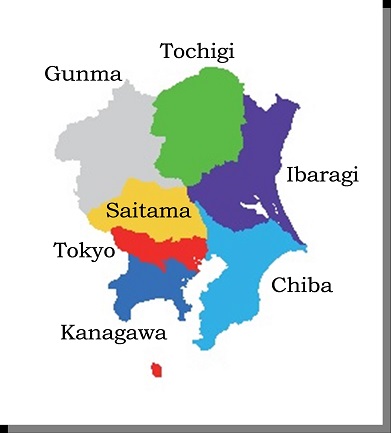
Tohoku is north of Kanto.
At the end of the Asuka Age, the Tohoku Area was formed to belong to Yamato Chotei, and in 802, the whole Tohoku area was conquered.

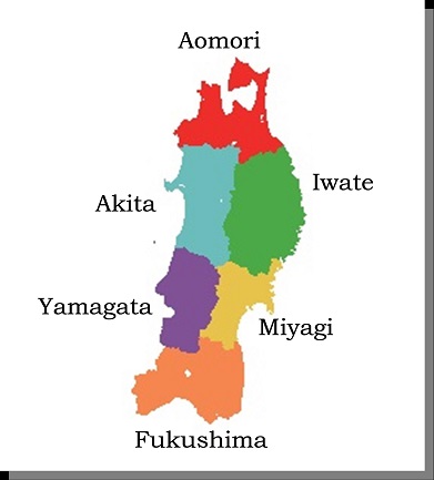
Tohoku contains, Aomori, Iwate, Akita, Miyagi, Yamagata and Fukushima Prefectures. Tohoku consists of Aomori, Iwate, Akita, Miyagi, Yamagata and Fukushima Prefectures. Iwate, Miyagi and Fukushima are located on the Pacific Ocean side, Akita and Yamagata are on the Sea of Japan side. Aomori is facing toward the Tsugaru Channel.

Right in the middle of Tohoku, the Ou Mountains run from north to south dividing the Tohoku area into the Pacific Ocean side and the Sea of Japan side. Along the Ou Mountains, there are a lot of hot springs.

On the north, the Tsugaru Peninsula and the Shimokita Peninsula protrude to the Tsugaru Channel. Also, Akita has Oga Peninsula, meaning male deer, on the Sea of Japan side and Miyagi has Ojika Peninsula, meaning female deer, on the Pacific Ocean side

Map of Tohoku
Travel Destinations in Aomori Travel Destinations in Aomori Travel Destinations in Akita Travel Destinations in Akita Travel Destinations in Yamagata Travel Destinations in Yamagata Travel Destinations in Iwate Travel Destinations in Iwate Travel Destinations in Miyagi Travel Destinations in Miyagi Travel Destinations in Fukushima Travel Destinations in Fukushima

The northern part of Tohoku is also cold and the Sea of Japan side of Tohoku has a lot of snow in winter. In summer, usually it is hot, but the Pacific side of Tohoku sometimes has cool east winds in summer, called "Yamase".

The Tohoku area is well known for summer festivals. "Nebuta" in Aomori and "Neputa" in Hirosaki. "Kanto Festival" in Akita, "Hanagasa" in Yamagata. Also, Sendai is famous for the "Tanabata" festival.

There are couple of historical spots in Tohoku. The ruins of Sannai Maruyama are from the Jyomon Age. The ruins of Taga Castle are from the Nara Age. In Hiraizumi, the Fujiwara family had their own nation at the end of the Heian Age. Aizu Wakamatsu, Sendai, Yonezawa, Yamagata, Morioka, Kakunodate and Hirosaki awere well-known in the Edo Age.

Also, beautiful mountains are in Tohoku. Mt. Hakkouda, Mt. Iwate, Mt. Iwaki, Mt. Chokai, Mt. Zao, and Mt. Bandai are famous mountains in Tohoku.

There are many beautiful and historical places to visit in Tohoku!

Kanto

Kanto is the area where Tokyo is located.
Kanto has seven prefectures. They are Gunma, Tochigi, Ibaragi, Chiba, Saitama, Tokyo and Kanagawa.

The largest plain in Japan, "Kanto Heiya" occupies approximately 1 / 3 of the Kanto Area. "Kanto Heiya" faces the Pacific Ocean on the east side. From the north to the west side of Kanto, mountains surround the area. Mt. Nantai san, Mt. Akagi, Mt. Tanigawa, Mt. Kobushigatake are famous mountains. In the south, the Boso Peninsula protrudes into Tokyo Bay.

Map of Kanto
Aomori Aomori

MINAMOTO NO Yoritomo established his government in Kamakura in 1185. Until 1333, Kamakura was the capital of Japan.
Also, TOKUGAWA Ieyasu located his capital at Edo, Tokyo, in 1603. After the Edo Age finished, emperors also started to live in Tokyo. At that time, Tokyo became the capital of Japan, both in name and reality.
Currently 1 / 3 of the population of Japan lives in the Kanto area, most of which are the in Tokyo area.

Kamakura unfortunately has no remaining traditional buildings from the 12 to the14th century, but it has many temples with good atmosphere. There are a few historical towns from the Edo Age. Kawagoe and Sawara are such examples. The grave of TOKUGAWA Ieyasu is at Nikko which includes many luxurious buildings.

Although Tokyo has become a mega-city with so many modern buildings, you will find scenery and sight locations from the Edo Age even in downtown Tokyo.

Chubu

Chubu means the central of Japan in Japanese.
In Chubu, there are nine prefectures. They are Niigarta, Nagano, Yamanashi, Toyama, Ishikawa, Fukui, Shizuoka, Gifu and Aichi.
As the Chubu area is wide from the Pacific Ocean to the Sea of Japan, including mountain areas, these nine prefectures are categorized into three regions. One is "Koushinetsu", which consists of Niigata, Nagano and Yamanashi. The second is "Hokuriku", which consists of Toyama, Ishikawa and Fukui. The last one is "Tokai", consisting of Shizuoka, Gifu and Aichi.

"Koshinetsu" is basically a mountain area. The Japanese Alps are located in this area. The Japanese Alps consist of three ranges; North, Central and South. The altitude of these mountains is around 3,000m.

Sado Island in the Sea of Japan is the largest island following the four big islands of Japan. It is located in Niigata Prefecture. Sado produced a lot of gold in the Edo Age.

Map of Chubu
Aomori Aomori Akita Akita

"Hokuriku" has rich rice fields and is well known for tasty rice. Niigata also has excellent rice. Hokuriku is said to be the most livable area in Japan. Traditional "Gassho Tsukuri" houses still remain in mountain areas near the border between Toyama and Gifu.

"Tokai" is the industrial area of Japan. The automotive and airplane industries are the main industries in this area. As NOBUNAGA encouraged free trading and commercialism 450 years ago, and TOKUGAWA Harunobu also encouraged commercialism in the Edo Age, productive industries have continued to thrive.

At the end of the Muromachi Age, powerful local clans expanded their territories. They were ODA Nobunaga, TOKUGAWA Ieyasu, IMAGAWA Yoshimoto, TAKEDA Shingen, UESUGI Kenshin, and others as well. There are many historical landmarks in this area related to them.

During the Edo Age, main roadways connecting Edo and Kyoto ran though this area. One is named "Tokaido" along the Pacific Ocean and the other one called "Nakasendo" runs through the mountain area in Nanano and Gifu. Post towns, "Shukuba Machi", still remain along those old roadways. Now, the Shinkansen runs along "Tokaido", through Shizuoka and Aichi prefectures.

Kansai

Kansai is the area where Kyoto and Nara are located. This area used to be the center of culture and politics in Japan. Osaka was also the center of the distribution industry during the Edo Age.

Because of this fact, there are very many historical shrines and temples located in this area. They include Ise, Kumano, Shimogamo and Kamigamo Shins, Horyu Ji, Todai Ji, Kofuku Ji, Enryaku Ji, Kongobu Ji. Many shrines and temples are located in Kyoto and Nara, but there are also many other historical spots widely locate in this area.

Not only emperors, but also ODA Nobunaga and TOYOTOMI Hideyoshi, originally from the Nagoya area, had their base in Kansai. Especially, Hideyoshi had his castle located in Osaka. Osaka Castle is the symbolic landmark for people in Kansai.

Map of Kansai
Travel Destinations in Kyoto Travel Destinations in Kyoto Travel Destinations in Nara Travel Destinations in Nara Travel Destinations in Hyogo Travel Destinations in Hyogo Travel Destinations in Hyogo
You can click each name or map of Prefecture for "Travel Destinations".

Kansai has nine prefectures. Those are Shiga, Kyoto, Nara, Osaka, Wakayama and Hyogo. Kansai people have different personalities compared to most Japanese. They have a good sense of humor and a lot of professional comedians are from this area.

The Kii Peninsula, the largest peninsula in Japan, occupies south of Kansai. Kii Peninsula is mainly mountain area. Kumano Kodo pathways, old pathways from Kyoto to Kumano Shrine, are located in this mountain. Novelists traveled on Kumno Kodo in the Heian Age.
The largest lake in Japan "Biwa Ko Lake" is located in Kansai.

Chugoku

Chugoku is located in the most western part of the main island "Honshu". The south part of Chugoku faces toward the Seto Inland Sea and the north part of Chugoku faces toward the Sea of Japan.

Chugoku Mountains divide Chugoku into the "Sanyo" side and the "Sanin" side. "Sanyo" implies sunshine and "Sanin" implies shadow. The Sanyo side has a lot of sunny days throughout the year. The Sanin side usually has rain and snow from late autumn to the beginning of spring.

Chugoku has five prefectures. They are Okayama, Hiroshima, Tottori, Shimane and Yamaguchi.
Okayama and Hiroshima are on the Sanyo side. Tottori and Shimane are on the Sanin side. Yamaguchi is on the west end of Honshu, facing both the Seto Inland Sea and the Sea of Japan. Sanyo is also an industrial area and the Sanyo Shinkansen runs through Okayama, Hiroshima and Yamaguchi. On the other hand, Sanin has less industrial output.

Map of Chugoku
Aomori Aomori Akita Akita

Izumo in Shimane was one of the main places described in the birth-myth of Japan. It is said that Izumo Shrine was built before the 1st century.
In the Asuka Age, the Yamato government built Kino Castle near Okayama city to prepare for war against Tang and Silla.

At the end of the Heian Age, Heike family who had power and became maternal relation with Emperor GOSHIRAKAWA, fell at Dannoura at the west end of main island "Honshu", in Yamaguchi. Yamaguchi again became the center stage of Japanese history at the end of the Edo Age.

Shikoku

Shikoku is a smallest island of the four major Japanese islands. It is located to the south of Chugoku across the Seto Inland Sea. Although Shikoku is a small island, many mountains occupy the island. Shikoku has the highest mountain in west Japan, named Mt. Ishizuchi.

Shikoku has four prefectures. They are Kagawa, Tokushima, Ehime and Kochi. Kagawa and Ehime are on the Seto Inland Sea side, and Kochi faces toward the Pacific Ocean. Tokushima is in the eastern part of Shikoku, facing the Kii Channel across Wakayama in Kansai.

Map of Shikoku
Aomori Aomori Akita Akita

Weather in Shikoku is warm, but high mountains have snow in winter. Sometimes typhoons hit Shikoku in autumn. On Seto Inland Sea side, there is less rain and is about the same as Okayama and Hiroshima in the Chugoku area.

As Shikoku is almost occupied by mountains, rivers in Shikoku are clear. The Shimanto River is one of the cleanest and clearest rivers in Japan.

Shikoku is well-known for Shikoku pilgrimage to the 88 temples. These temples, related to "KUKAI", brought Shingon Esoteric Buddhism in the 9th century from China. KUKAI was born in 774. He built Koyasan Temple in Wakayama Prefecture in 816, with the permission of the Emperor.
The Konpira-san Shrine is also famous. This shine was built sometime between 701 and 704.

Kyushu

Kyushu is located on the west side of Japan. It is very close to the Korean Peninsula. In Kyushu, some of the cities located there are Fukuoka, Saga, Nagasaki, Kumamoto, Oita, Miyazaki and Kagoshima. After the Meiji Age, Okinawa was also included as part of the Kyushu area.

Kyushu has a lot of volcanoes. Major volcanoes are Aso in Kumamoto and Kirishima and Sakurajima in Kagoshima. Those volcanoes are still active.

Weather in Kyushu is warm. They sometime have heavy rains at the end of rainy season in July. Typhoons often strike Kyushu in autumn.

Map of Kyushu
Aomori Aomori Akita Akita

Kyushu is in rich in historical places.
The ruins of Yoshinogari are good example of "Kuni" from the Yayoi Age. Before recorded history, Takachiho in Miyazaki, was one of the main places described in birth-myth of Japan.

Because of its location, Japan introduced a lot of culture from the Korean Peninsula through Kyushu. "The golden seal of the King of Japan, Chinese Colony" was found in Shikano Shima Island, which was given by the Chinese emperor to the Japanese emperor in the 1st century. Dazaifu in Fukuoka was a department of the central government in the Nara Age.

During the Edo Age, Nagasaki was the only place open for foreign country entrance. At the end of the Edo Age, Kagoshima and Saga were the leading positions to defeat "Tokugawa Bakuhu".

During World War II, kamikaze air planes on suicide missions took off from Navy bases in Kyushu. Chiran was one of such Navy bases in Kyushu.

Okinawa

Okinawa is located on the southwestern tip of Japan. Okinawa consists of 365 islands and these island are widely spread with 1,000km distance from the North Daito Island in the eastern most island of Okinawa to the Yonaguni Island in the western most island in Japan. The distance between Yonaguni Island to Taiwan is just 111km. You can see Taiwan from there when the weather is clear.

Okinawa is in a subtropical zone, so the weather is warm even in winter.

Map of Okinawa
Aomori Aomori Akita Akita

Okinawa used to be an independent country from Japan.
In 1429, Shou-Hashi King established the Ryukyu Kingdom. In 1609, Shimazu in Kagoshima was added to the Ryukyu Kingdom. After that, the Ryukyu Kingdom belonged to both the Qing Dynasty and Japan.

During World War II, the main island of Okinawa became a battlefield. After World War II, Okinawa was occupied by the United States until Currently, Okinawa has 75% of exclusive facilities of US forces in Japan.

Because of the historical reasons, Okinawa has their own unique culture. Styles of building are also different from other areas in Japan. One of the reasons for house styles in Okinawa is due to strong typhoons striking the region.